In Haruki Murakami’s 村上 春樹 A Wild Sheep Chase 羊をめぐる冒険, a man searches for an obscure mountain field in Hokkaido on the basis of a single photograph; the picture contains few identifying features other than a sheep with a star-shaped mark on its back. Despite scant evidence, the protagonist reaches his goal through dogged determination.
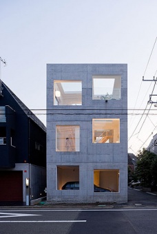
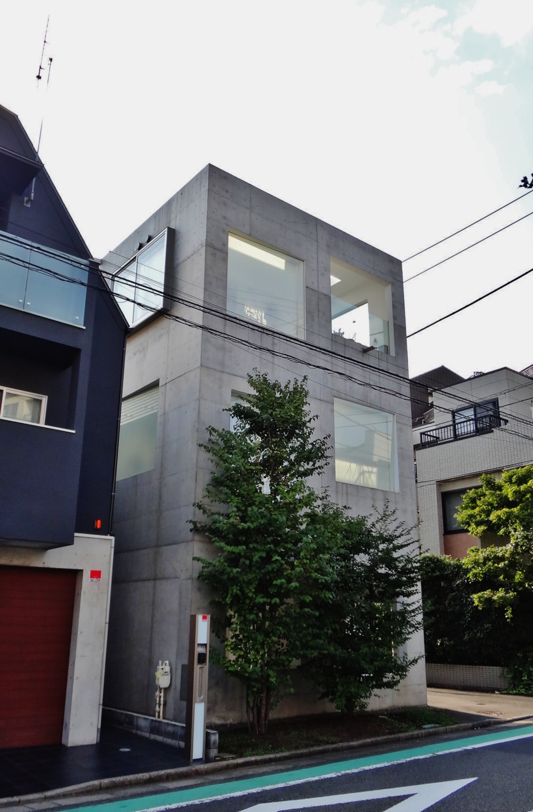
House H before the tree
Hide-and-go-seek-and-go-seek-again
In a prior post I described House NA, the glass house made even more invisible by Japanese privacy law, which (I assume) prohibits posting the addresses of private homes, as such information is not available online. In my entry I (hopefully) skirt the law by explaining how I located the noteworthy structure using a string of clues gleaned from the internet. For people with a decent knowledge of Tokyo’s geography, basic map reading skills, and some patience, finding House NA is not particularly difficult. In short, there is nothing to brag about.
Stalking the wild Sou Fujimoto
Fresh off my success with House NA I assumed that finding any of the works by Sou Fujimoto Architects 藤本壮介建築設計事務所 would require a similar level of effort. While a work such as Tokyo Apartment is easy to find, locating the minimalist House H is no simple task. In several frustrating and aborted attempts, I concluded that House H was out of reach – I found some pictures online but knew only that it was located in “Tokyo”, the second largest urban land area in the world. Months later I returned to the challenge with renewed enthusiasm. Starting with two photographs as points of reference, I made a series of deductions and educated guesses, eventually landing myself at the door of House H.
None of this would have been possible were it not for my exhausting and exhaustive walking tours of Tokyo, which led my intuition to select the wards of Setagaya 世田谷区 and Suginami 杉並区 as the most likely location for House H. This was based on certain observations from Clue B: the size and age of the houses, the golf driving range, the existence (and small number of) taller buildings in the distance. A Google search such as “House H Setagaya” led me to a blog that confirmed my hunch. This narrows the location, but only to a degree. Setagaya-ku is, after all, about the same size as Newark, NJ.
Here’s the trail of breadcrumbs I followed.
The two initial clues:
Clue A: provides some direction

Clue B: the key photograph
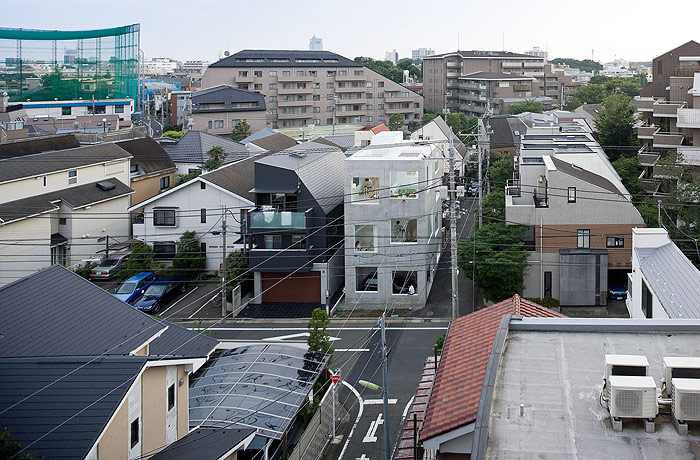
In Clue A we see that the trees on the left of the frame have no leaves, so we can assume that the season is winter, or the late/early edges of fall/spring. We see the sun streaming from the right, running roughly parallel to the main road that House H sits on. Since this is winter, we know the sun rises somewhere south of east and sets somewhere south of west. Based on the color of the light, we can guess that the photo was taken neither at sunrise or sunset, and so is more likely to be coming from a southerly direction at this point. As a rough rule-of-thumb, I assumed that the road to the right was “south”, meaning that the house faces “east”. (In actuality, House H faces east-northeast, and the road to the right runs south-southeast.)
From Clue A, we also see a mild curve in the street across the road from the House H. Combined with the dead-end street running adjacent to House H (as seen in Clue B), we know the shape of the intersection (a T with one dead-end and one slightly curved branch. And from above, we know, within reason, the house’s orientation. This will be helpful once we narrow the location to a smaller area.
On to Clue B…
See that tall building in the background, slightly left of center?
Using a Google and/or image search for keywords such as “tall buildings in Setagaya” (in Japanese, mostly), I found the following photo which, after some internal debate, I concluded is the same building as that seen in Clue B.
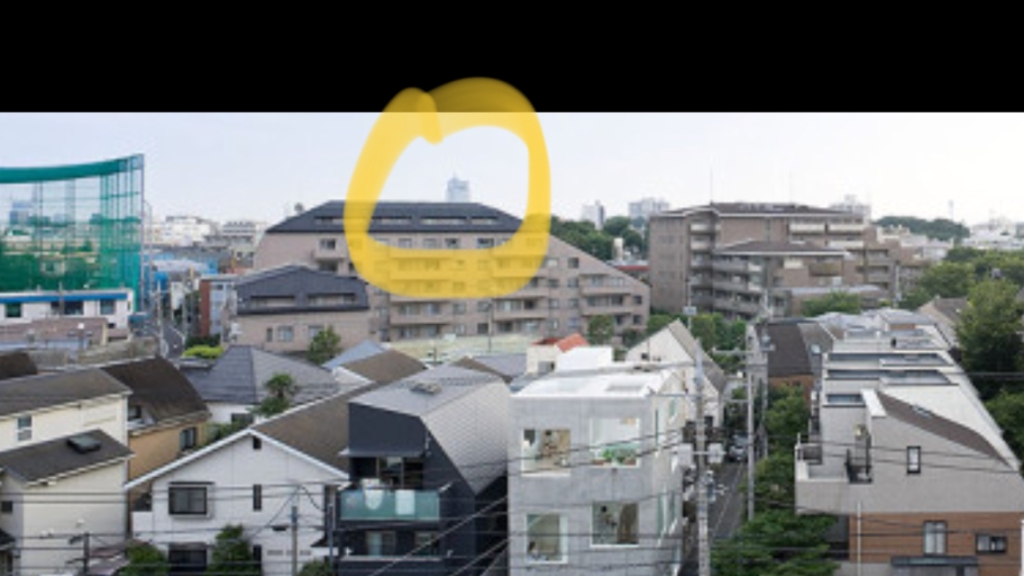
Clue C:

Using the image from Clue C, I performed a reverse Google image search to see if other websites were linking to this picture. From two of the results it became clear that Clue C is a still from a video taken filmed from the top of a building in Sangenjaya 三軒茶屋.
One site has the description:
箱根山に沈む夕陽を三軒茶屋キャロットタワー展望階から // The sun set in Hakone from Sangenjaya Carrot Tower Observatory floor.
Another links to the YouTube video from which this frame originated. The video opens with the title, “Tokyo Skyline from Carrot Tower Sangejaya”. The cameraman jumps around a bit, occasionally zooming in on the building from Clue C:
Clue D: Mt. Fuji straight ahead

Clue D is a still taken from the video at 1:21. Knowing the orientation between Sangenjaya and Mt. Fuji, we can tell that the building in Clue D sits in a westerly direction, with Mt. Fuji located in the hazy distance at west-southwest.
Because we know that House H roughly faces east, we know that the tower from Clue B is west of House H. And because there are no other taller buildings in the background of Clue B, we know that Carrot Tower キャロットタワー (a tall building) is “behind” the camera in Clue B, i.e. east of House H. Hence, House H is located somewhere in between Carrot Tower and the Clue C tower.
The YouTube video shows us that the Clue C tower is located next to a major road. A search on Google streetview reveals that Clue C tower is Setagaya Business Square (SBS Tower) 世田谷ビジネススクエアタワー (map), located next to Yōga station 用賀駅.
Here’s a map that describes all the craziness that I attempted to explain above:
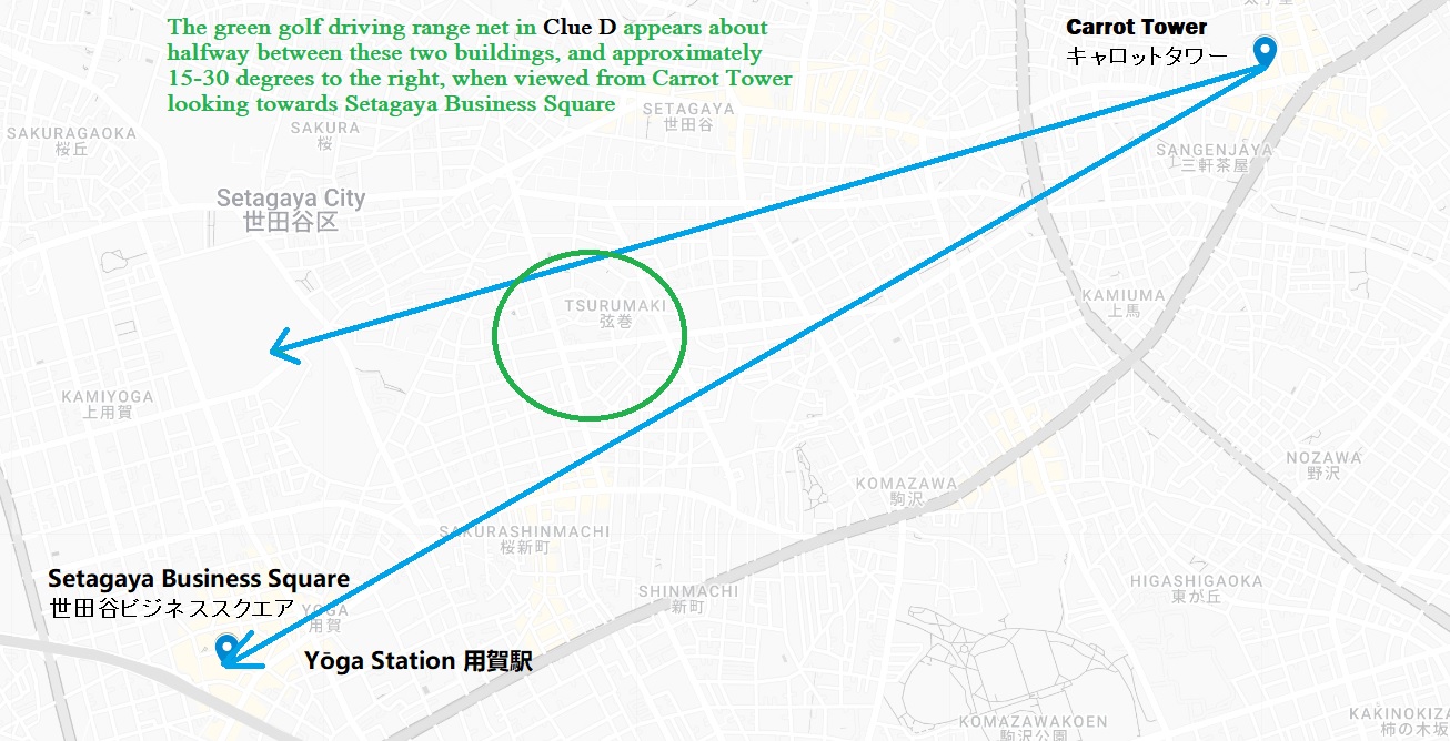
The distance between Carrot Tower キャロットタワー (located adjacent to Sangenjaya Station) and SBS Tower is just 2.5 miles; in Clue B, House H doesn’t appear very close to SBS Tower, so I made the assumption that House H is minimum of 1 mile away from SBS Tower. This wasn’t enough information, and I unsuccessfully tried with brute force and Where’s Waldo levels of concentration to match the intersection from Clue A with the hundreds of tangled streets that lie between the two towers.
The final piece of evidence came courtesy of one of the salaryman’s favorite pastimes: hitting golf balls. In Clue B, we see at the left of the frame a driving range with its telltale green netting. I did a Google map search for ‘golf driving range’ in Japanese, ゴルフ練習場, and noted only two or three between SBS Tower and Carrot Square. It then didn’t take long to find an intersection that matches the one noted in Clue A. Google streetview confirmed the results.
(For some more golf-related content, see: Kobe, taxes, and hills: the golf courses of Hyogo Prefecture)
A few weeks later I visited House H in person to celebrate:


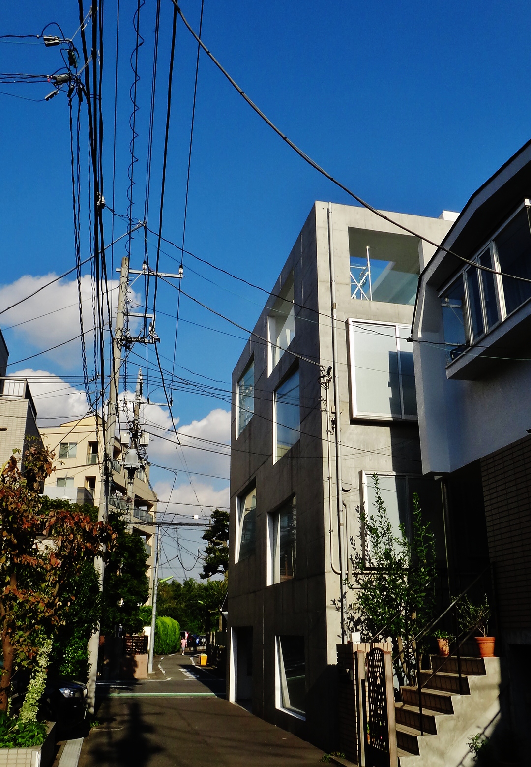
Can you find House H?

Links:
- Removing what isn’t there (how to find the works of Sou Fujimoto) 「場所藤本壮介-house」
- Minimalist House H in Tokyo by Sou Fujimoto Architects
- Sou Fujimoto Architects 2008 House H
- A self-drawn map of a sanpo along the Sengawa river, including the Toho Godzilla statue, Sou Fujimoto’s House H, and Sakurashinmachi: map photo


I failed to find it