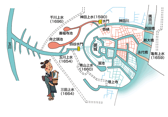
Map of rivers and canals in central Tokyo. Clockwise from left:
玉川 (or 多摩川) = Tamagawa
千川上水 = Senkawa Josui (1696)
神田上水 (1590) = Kandagawa-josui
神田川 = Kandagawa River
隅田川 = Sumidagawa
亀有上水 (1659) = Kameari Josui
The three bridges are:
1) 両国橋 (Ryōgokubashi)
2) 新大橋 (Shin-Ohashi)
3) 永代橋 (Eitaibashi)
増上寺 = Zojo-ji
三田上水 (1664) = Mitagawa
青山上水 (1660) = Aoyama josui
玉川上水 (1654) = Tamagawa josui canal
四谷水門 = Yotsuya suimon
井之頭池 = Inogashiraike pond
善福寺池 = Zenpukuji pond, which feeds the Zenpukujigawa 善福寺川
御城 = Edo Goshiro 江戸御城, aka Edo Castle 江戸城
