New York has its High Line. Seoul has Cheonggyecheon 청계천 清渓川, a glorious urban river in the heart of the city. What does Tokyo have? A lot, it turns out. There are countless miles of pedestrian paths and “green roads” that follow the route of old rivers and streams. They may not be well-publicized, but they are EVERYWHERE, as I would find out. This post is in part a history, in part a travel guide, and completely an obsession of mine. I’m not alone…a recently published book is titled 『 暗渠マニアック!』 (Ankyo Maniac), or “Culvert Maniac!”. And I’ve recently been following a growing number of culvert fanatics on Twitter.
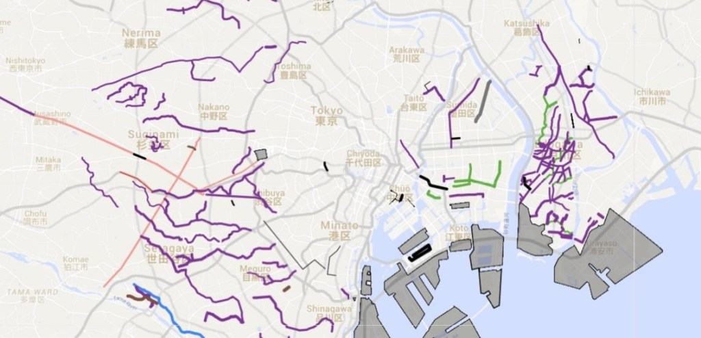
In-progress map of Tokyo’s underground rivers and reclaimed land:
Introduction:
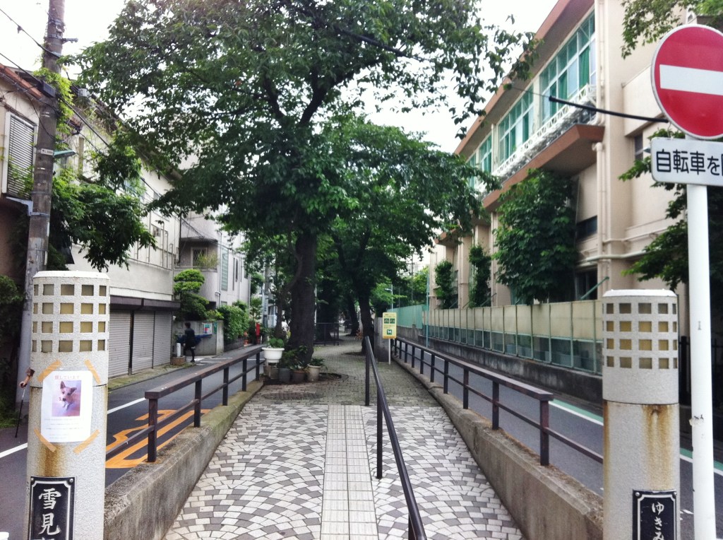
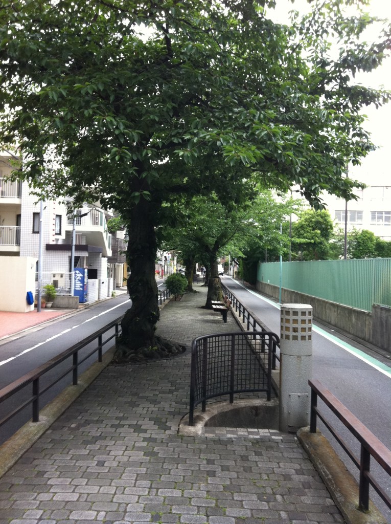
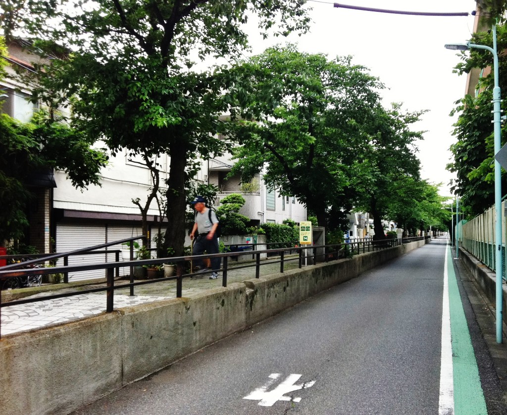
It started with an observation: a street with a raised path running down the center of the road. The path was landscaped like a park, with trees, paving stones, and the occasional bench.
Were these the remains of a defunct streetcar? They reminded me of the grassy median of the old Middlesex and Boston Street Railway that used to run down Commonwealth Ave in Newton, Massachusetts:

I kept seeing these patterns in places so far from the center of Tokyo that a streetcar line seemed implausible. These weren’t streetcars, they were defunct rivers, a thought I arrived at via logic, plus references in articles like this:
“Sendagaya…also has subterranean history: Beneath the neighborhood flows the Shibuya river, which was paved over in advance of the 1964 Tokyo Olympics, when the area was drastically altered to make way for the National Stadium and its access roads.”
From “DRAWER OF MEMORIES: Haruki Murakami rose to fame from a ‘walled town’ of a Tokyo neighborhood, The Asahi Shimbun, circa July 27, 2014; no longer available online.
Tachiaigawa green road
The example I first mentioned is now called Tachiaigawa green road 立会川緑道 in Meguro-ku (map), and runs from Himonya Hachiman-gu 碑文谷八幡宮 shrine in the west to Yukimi-bashi in the east, then turns sharply to the southeast, crossing the old “Meguro Kamata Electric Railroad”. Seen in a 1948 map, this used to be the Tachiaigawa river 立会川 ; the current river exists only briefly, emerging from underground a few hundred meters inland from Tokyo Bay.

The Tachiaigawa Green Road reminded me that Tokyo is a city of rivers, streams and canals, many of which I’ve walked along. Despite my firsthand knowledge of the Kanda River, Tawagawa Josui, and others, I still used to look at old maps of Edo/Tokyo with a healthy dose of skepticism. It didn’t really look like this, I would think…

The old Edo maps seemed to overstate the importance of rivers, and I assumed artistic license must have been at play, like those medieval paintings that played fast and loose with concepts of perspective…

…but I’ve come to discover that these old maps were quite accurate, and may even have understated the amount of moving water in Tokyo/Edo. I found this out firsthand when attempting to map ALL of the underground rivers and streams in Tokyo.
PART 1: Water you can see
There are many types of moving water in Tokyo. There are the mega-rivers: the Tamagawa, Sumida, Arakawa, and Edogawa. And there are over 100 small and mid-sized rivers and canals such as the Kanda, Meguro, and Zenpukujigawa rivers, all part of a larger river system; the Tamagawa and Arakawa river systems are each responsible for about 40 tributaries 支流. In addition, there are unnamed streams and irrigation channels, followed by countless drainage ditches and culverts.
The mega-rivers and many of the mid-sized rivers are visible today, but a tremendous amount of moving water was moved underground or diverted in the second half of the 20th century as part of Tokyo’s continual urban development. Today you are more likely to see examples of smaller streams in more remote areas of the city. Here’s an example of a drainage ditch in Mitaka (map):


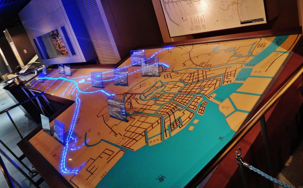
Tokyo’s system of rivers and streams owes as much to man as it does to nature: many of the water that reaches the city’s center is the result canals and aqueducts that were built centuries ago. The development of this system is explained at the satisfying Tokyo Waterworks Historical Museum 東京都水道歴史館 (below left). The map, below right, provides a nice overview of these systems.1
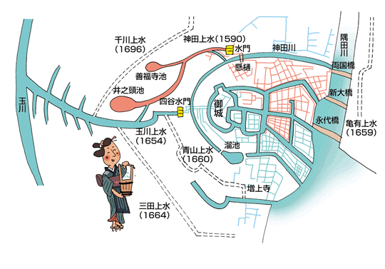
In the map we see (clockwise from left):
- 玉川 (or 多摩川) = Tamagawa
- 千川上水 = Senkawa (Sengawa) Josui (1696)
- 神田上水 (1590) = Kandagawa-josui, formerly Koishikawa [below here is a 水門 suimon, a floodgate or sluice]
- 神田川 = Kandagawa River
- 隅田川 = Sumidagawa
- 亀有上水 (1659) = Kameari (Honjo) Josui, aka 本所上水,「本所(亀有)上水」2
The three bridges are: 両国橋 (Ryōgokubashi), 新大橋 (Shin-Ohashi), 永代橋 (Eitaibashi)
- 増上寺 = Zojo-ji (the temple next to Shiba Park and Tokyo Tower)
- 三田上水 (1664) = Mitagawa
- 青山上水 (1660) = Aoyama josui canal, across from which is 溜池 (Tameike), which means reservoir, also known as ひょうたん池 (hyoutan-ike), gourd pond, due to its shape
- 玉川上水 (1654) = Tamagawa josui canal
- 四谷水門 = Yotsuya suimon (Yotsuya water gate)
- 井之頭池 (井の頭池) = Inogashiraike (pond)
- 善福寺池 = Zenpukuji pond, which feeds the Zenpukujigawa 善福寺川
- 御城 = In the middle is Edo Goshiro 江戸御城, aka Edo Castle 江戸城 (image)
PART 2: Water you can’t see
You know that extinct river in Meguro-ku that I mentioned, the Tachiaigawa? It’s not alone. Back when I started this post I had planned on describing the 5-10 examples of former rivers that I knew about. And I started mapping them. And as I mapped them I noticed that the former river fit into certain patters. And the more I noticed these patters, the more former rivers I would find. What patterns did I see? Here are some of them:
a) green median-strips
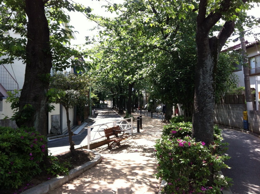
This type of former river is easy to spot, and often the most beautiful. Kuhonbutsu River Green Road 九品仏川緑道 in Jiyugaoka is a classic examples. In this map, the river’s route is easily visible. The red X at the right is the former river’s outlet.

And here’s a view of Jiyugaoka’s green road from the ground.

b) parallel lines curving in unison
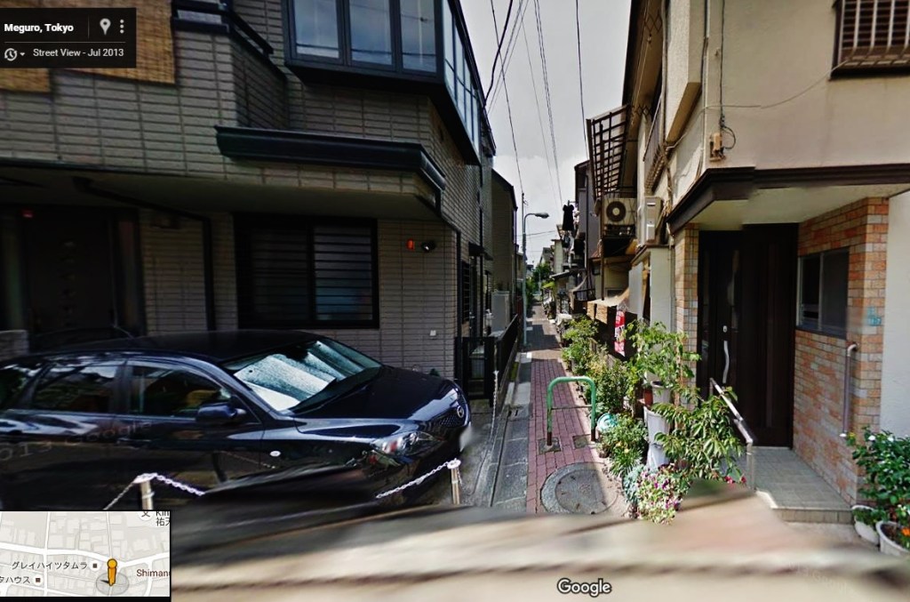
This is basically the same as above, except that a green median-strip is not visible. Here’s an example of a map, and StreetView (map):


c) gray lines (suggesting the absence of houses)
This is the type of pattern that became more obvious to me the more I stared at the maps…grey lines that subtly make themselves known due to the absence of houses or other features.
Take these two maps from Chitose-Karasuyama station (map). Do you see the hidden rivers and streams?
Here’s the same map (below, left), with a thin black line indicating where the former river is located. A small cross marks the center of the map, and corresponds to the red circle from a map of the area from 1945 (the indispensable US Army survey maps). In 1945 a stream is clearly visible:

Here’s a view of the path from today (facing north):

d) disappearing rivers
These are fun to spot: visible rivers that occasionally (or permanently) become hidden. Their subsequent paths are often easy to trace: (example map)

e) narrow lines too narrow for cars (suggesting drainage/irrigation ditches)
Many of the very narrow roads on Google Maps are actually former streams or drainage ditches. Some of these appear as streams on the 1945 map. Others, such as the example below, do not appear on the 1945 map, but I validated they were former streams based on other sources.
Seen below left, the Yatomaegawa Green Road 谷戸前川緑道 is a thin road running horizontally across the map; it’s not obvious from this view that this isn’t simply a narrow road. However, as seen from StreetView, below right, this is obviously a pedestrian path.

f) parks with visible water
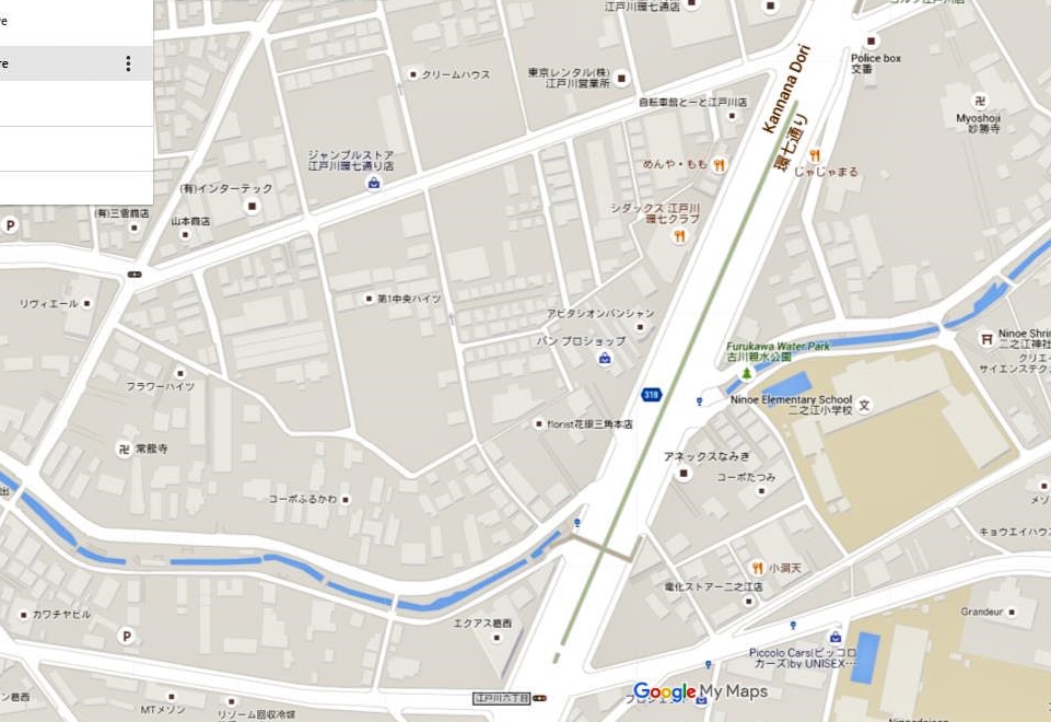
Although most items that I mapped are HIDDEN rivers and streams, I have also included bodies of moving water that were dramatically altered, often into the form of parks. These are mostly in Koto-ku or Edogawa-ku and were former canals/rivers that cut through the city for trade, navigation, etc. Although some water is still visible, these streams no longer perform their original function and are now used for recreation. Below, for example, is Furukawa Water Park 古川親水公園 in Edogawa-ku (map).

g) major aqueduct projects
The last form that I will describe are the water service roads 水道道路 (すいどうどうろ、または「 水道道 」 (suidodoro), which were built during the construction of major aqueduct projects (aka water pipe roads). These roads are extremely straight and have largely been turned into major roads. However, a section of one of these water service roads is now a bike path: Sayama Green Road. These roads include:
- Sayama Sakai Scenic Road (Green Road) 狭山・境緑道, aka Tamako bike path / 東京都道253号保谷狭山自然公園自転車道線 (Tokyo No. road 253 Hoya Sayama nature park bicycle path line)
- Aratama Aqueduct: 荒玉水道道路 AraTama water road (Aratama suidō dōro), aka (東京都道428号高円寺砧浄水場線 (Tokyo No. road 428 Koenji Kinuta water purification plant line)
- 東京都道431号角筈和泉町線 Tokyo Road 431 No. Tsunohazu Izumi-cho line, which feeds into the old filtration fields in Shinjuku
- Inokashira-dori 井ノ頭通り (Tokyo Aqueduct): “The Inokashira Pond there was the source of the first water service for Tokyo (then called Edo), the Kanda water supply, providing a vital roll until an improved water supply was completed in 1898.” 3
Other
These patterns describe most of the former rivers. Additionally, I have mapped some of the major reclaimed land areas, and in a few instances, have mapped walking paths that are the result of defunct streetcar lines.
The map is certainly a work in progress, and I am somewhat less committed to mapping Koto-ku and Edogawa-ku, as those wards consist largely of reclaimed and drained land; as a result, rivers, canals, and drainage ditches can be found under virtually every road.
Part 3: The map
The map above, and list below, is a work-in-progress collection of various underground rivers, hidden streams, green roads, and major land reclamation projects in Tokyo.
The list (in no particular order):
- (1) Tachiaigawa green road 立会川緑道 (Meguro-ku) (map)
- (2) Sayama Green Road 狭山・境緑道 (Sayamasakai), aka, 東京都道253号保谷狭山自然公園自転車道線, aka 多摩湖自転車道 Tamako bike path
- (3) Nomigawa Green Road 呑川本流緑道 / 呑川緑道 (Sakurashinmachi to Toritsudaigaku) & (3B) “Shinagawa ditch”
- (4) Kakinokizaka green road 呑川駒沢支流緑道
- (5) Kuhonbutsu River green road 九品仏川緑道 (Jiyugaoka)
- (6) Rakan-ji River green road 羅漢寺川緑道 / Shinagawa Aqueduct (north of Rinshi No Mori Park) & (6B) “Shinagawa Ditch”
- (6C) “Rokusekawa Promenade” 「六畝川プロムナード」
- (8) Yatomaegawa Green Road 谷戸前川緑道 (Yatomaegawa midori michi)
- (9) Also near old Olympic Komazawa park
- (9) Nomigawa Kakinokizaka shiryu (tributary) Ryokudo Green Road 呑川柿の木坂支流緑道
- (10) Senzokuike 洗足池 and Senzoku stream 洗足流れ
- (11) Tamagawa Josui canal 玉川上水緑道 (from Kamikitazawa to west Shinjuku area) and (12) Tamagawa josui branch to Yoyogi-hachiman and Shibuya (road)
- (13) Yahatagawa Kita Midori michi 谷端川北緑道 & Yahatagawa Minami Midori michi 谷端川南緑道 (north & south Pedestrian Street)
- (14) Senkawa-josui green road 千川上水緑道 (Kyu-Sengawa aqueduct)
- (17) 出井川緑道 Idei River green road
- (19) Jakuzure River green road 蛇崩川緑道 (Shibuya Aqueduct per 1945 map)
- (19C) Sakurashinmachi Kitasho Ryokuchi Park 桜新町北小緑地
- (22) feeds the Myoshojigawa 妙正寺川 みょうしょうじがわ (narrow, pedestrian only)
- (23) Kitazawa-gawa ryokudo Green Road 北沢川緑道
- (24) Karasuyamagawa Ryokudo Green Road 烏山緑道 / 烏山川緑道 and Pedestrian Road (Karasuyama Ditch)
- (25) Zenpukuji-gawa 善福寺川 old routes
- (26) Taoyuan River green road 桃園川緑道 (Toengawa Ryokudo) – Kandagawa Canal System (Great photos from “The Lost Rivers of Tokyo“)
- (27) へび道 Snake Road (Hebimichi) ROAD
- (28) Shibuya-gawa 渋谷川 – road, much of it a pedestrian road
- (29) Tagara River green road 田柄川緑道 (great photos)
- (37) Zempukujigawa 善福寺川, old course of river, small section, narrow roads
- (38) Nomikawa old course
- (GR 39) Nukuigawa Green Road 貫井川緑道
- (45) Takashimadaira Ryokuchi Park 高島平緑地 – old stream path running under a remodeled promenade and waterway (PDF)
- (50) Sanyabori Canal 山谷堀
- (200) Rokugo Irrigation ditch
- (202) Tanigawa Ryokudo 谷川緑道 – path and road
- (203) Tamagawa Electric Railway 玉川電気鉄道 (former streetcar)
- (205) 六郷用水路: 南堀 (大堀) Rokugo water canal: Minamibori (Large canal)
- (300) Sendaiborigawakoen 仙台堀川公園 Green path
- (301) Yokojukkengawa Water Park 横十間川親水公園 (Green path) よこじっけんかわしんすいこうえん – amusing adventure park for children, with rope bridges and a zip-line (see item #8, Jitsuken River Water Park 横十間川親水公園, map)
- (302) Furuishiba River Water Park 古石場川親水公園 (Green path)
- (303) Susakigawaryokudo Park 洲崎川緑道公園
- (304) Oyokokawa Water Park 大横川親水河川公園 Green road (little visible water)
- (305) Naka-bori ditch (road, not green)
- (310) Ojimaryokudo Park 大島緑道公園 (Old Streetcar)
- (311) Kameidoryokudo Park 亀戸中央公園 (Old Streetcar)
- (312) Tategawa riverbed park 竪川河川敷公園 (Kenkawa riverside park) (visible water, park, sports facilities…all under an elevated highway. Very interesting space)
- (401) Komatsugawa Sakaigawa Shinsui Park Green road 小松川境川親水公園
- (403) Ichinoe-Sakaigawa River shinsui park (Green Road) 一之江境川親水公園 (visible water) [See the excellent presentation, Restoration of once-lost urban river – Focused on the Case in Edogawa City, Tokyo, Japan by The Japan Riverfront Research Center, NOBUYUKI TSUCHIYA, Director]
- (404) Furukawa Water Park 古川親水公園 (Green path, visible water)
- (407) Sakongawa shinsui Green road 左近川親水緑道 (visible water)
- (410) Nakaibori ShinsuiGreen Path
- (412) Old Sumidagawa 古隅田川 (Furu-Sumidagawa)
- (415) Kasai yosui hydrophilic waterway Green Road 葛西用水親水水路 Kasai yousui shinsui suiro (visible water)
- (416) Hikifunegawa shinsui Koen Green Road (Towing River Water Park) 曳舟川親水公園 (visible water) (See here for historical overview), and (416B) Hikifune-gawa road 曳舟川 (Towing River) (not green)
- (420) Shishibone shinsui green road 鹿骨親水緑道 (some visible water)
- (421) Nagarehori shinsui flower road 流堀親水はなのみち
- (423) Kouno shinsui hydrophilic green road 興農親水緑道
- (424) Hongo Yosui Shinsui Green Road 本郷用水親水緑道 (some visible water)
- (430) Shin-Sakongawa Shinsu Park 新左近川親水公園 (reclaimed land park) – looks like a good BBQ spot
- (432) Nishi-koiwa Shinsui Road 西小岩親水緑道 Nishikoiwa shinsui midori michi
- (435) General Recreation Park (Edogawa) 総合レクリエーション公園
- (460) Toneri green road park 舎人緑道公園, or Shinryo moat hydrophilic green road 神領堀親水緑道
- (700) 野火止用水(のびどめようすい、のびとめようすい)Nobidome water (Nobidome-yosui canal, Nobitome-yosui canal), aka 伊豆殿堀(いずどのぼり) (Izudonobori) – Most of this water is visible / a special section of this canal is (700A) 本多緑道 Honda Ryokudo (Honda Pedestrian Path), which is nestled in a thick forest.
- (701) Negawa Ryokudo 根川緑道 Green Road (visible water), connected to Tachikawa park 立川公園
- (702) Shimogawara Freight line Pedestrian Road 下河原線緑道
- (703) Zoudabori Park Green Road 雑田堀緑道 ぞうだぼり Zodabori
PRIMARY SOURCES:
- Logic
- Japan Maps (including detailed Tokyo and other city maps from 1945): Perry-Castañeda Library Map Collection, University of Texas Libraries
- Geospatial Information Authority of Japan (GSI): Access via HERE (click on the “GSI Maps” link)
- Tokyo Mapping Resources (the tokyo files maps)
- Edogawa City Mapping tool 江戸川マップ 地図を見る(えどがわマップへ)
- Our Motto is Our Motto is “A Green Earth, A Rich Heart A Green Earth, A Rich Heart” Edogawa City Edogawa City” (Maps of Edogawa green roads)
- 尊い東京の姿 (Precious Tokyo Sights) (Maps of Koto-ku old streetcar/Toden lines
- Tamagawa area: http://tokyoriver.exblog.jp/18149330
- Rokugo Canal Map 六郷用水 地図 (and blog)
- Setagaya ward list of green roads / midori-michi / ryokugo 緑道 4
- Update: I have also started to consult the following blog, which has extensive research on individual streams and culverts: 毎日暗活!暗渠ハンター (旧『東京Peeling!』)
GLOSSARY:
- 緑道 (ryokudo, though I’ve also seen “midorimichi”) = green road / pedestrian path / green way / pedestrian mall – this term is applied to a sidewalk or paved path that runs along trees, grass, a stream, etc. Green roads are often built on the site of an old canal, river , or defunct railway line. Green roads are used both for pleasure, like a park, and also just for pedestrian access from A to B, depending on where they are built.
- In my personal usage, a “pedestrian path” refers to all paths that are different from a standard sidewalk (sidewalk, meaning, a raised pedestrian walking surface that borders a road). “Green road” is used for a pedestrian path that has greening elements like trees, a stream, etc.
- 親水緑道 = Hydrophilic green road [親水 (shinsui)= Hydrophilic, or, easy access to water]
- 親水公園 = Hydrophilic park (shinsui koen) – similar to the above, but presumably more “park-like” (e.g. a place to gather) rather than just for walking
- 遊歩道 (Yūhodō / Yohodo) = promenade / esplanade = a green road may also be described as a “promenade” if it is shorter in length, especially if the promenade is located in an urban center, where the path is intended for strolling and park-like activities.
- 廃線 (haisen) = discontinued line, waste line, spent line = this is a former railway or streetcar; their tracks are sometimes recycled as pedestrian paths
Water terms:
- rainwater collects into the “grooves” 「どぶ」 (dobu).
- 公共溝 = public groove / public ditch (drainage ditch, e.g.)
- 水汲 (mizukuma) = pumping water, drawing water
- 分流 (bunryū, bunryu) = split flow, tributary, water diversion, water separation, distributary, diverging shunt
- 用水路 (Yōsuiro / Yosuiro) = irrigation channel / irrigation canal / irrigation ditch
- 分水路 (bunsuiro) = divided waterway, flood-control channel, diversion canal, spill way
- 水門 (suimon) = sluice, water gate, sluice gate, floodgate
- 暗渠 (ankyo) = culvert, drain
- 上水 (jōsui, josui) = water supply, canal, aqueduct, waterworks, clean water – when used to describe a specific waterworks project, such as the Tamagawa Jōsui 玉川上水, the word 上水 jōsui is probably best translated as canal or aqueduct. For clarity, I desribe such a project as the “Tamagawa josui canal” or “Tamagawa josui aqueduct”. That work, specifically, is a 43 km canal that diverts the Tamagawa River to central Tokyo. It is no longer used for drinking water but much of the canal remains.
- See also: River Glossary
Further reading & related links:
- The Canals of Ginza: floating through time on Tokyo’s central waterways
- Civil Engineering Photos 土木工事写真集
- Yotsuya area
- Tunnel near Meguro 5 6
- Kandagawa is actually Kandajosui 神田上水, a canal system (source).
- Mitagawa = (see external blog map; external blog site) (Other good blog; elevated canal)
- Adachi-ku list of parks
- The Asahi Shimbun article referencing Sendagaya: (broken link) ajw asahi com/article/behind_news/people/AJ201407270009
- The Japanese website, River Promenade 川のプロムナード, was an excellent resource, but appears to be offline now (broken link: riverpromenade blog fc2 com)
Footnotes:
- Gakken Science Creation Institute 学研科学創造研究所: Edo’s Waterworks 江戸の上水 ↩︎
- Exploring the Water Systems of Edo and Tokyo: A Journey Through Water Heritage 江戸・東京の水利探訪 水利遺産探訪 (PDF) ↩︎
- Inokashira Park (PDF) ↩︎
- Setagaya Ward Parks and Greenways 公園・緑道 ↩︎
- Tracing History: The Mita Waterway 歴史を訪ねて 三田用水 ↩︎
- Chapter 7, Section 5: Saigoyama and Daikanyama 第七章・第五節/西郷山と代官山 ↩︎

That was an amazing lecture! Can’t wait to spot those old river next time visiting Tokyo :). Heading to read more of your posts! Thank you for your hard work!