Nanatsuji 七辻 seven-way intersection

Nanatsuji 七辻, an unusual 7-way intersection in Ota-ku, halfway between Zoshiki Station 雑色駅 and Kojiya Station 糀谷駅 (map).

Aerial view:

View from the street:

See original post: (390 thru 398) Nanatsuji 七辻 seven-way intersection

Note: this intersection is located on or near the original location of the old 六郷用水 Rokugo yōsui irrigation system, aka the Rokugo Canal, which lends its name to a Ward within Ota-ku today.

At the southern border of Ota-ku is Rokugōdote Station 六郷土手駅, also named for the canal.

the tokyo files: danchi 東京団地萌え

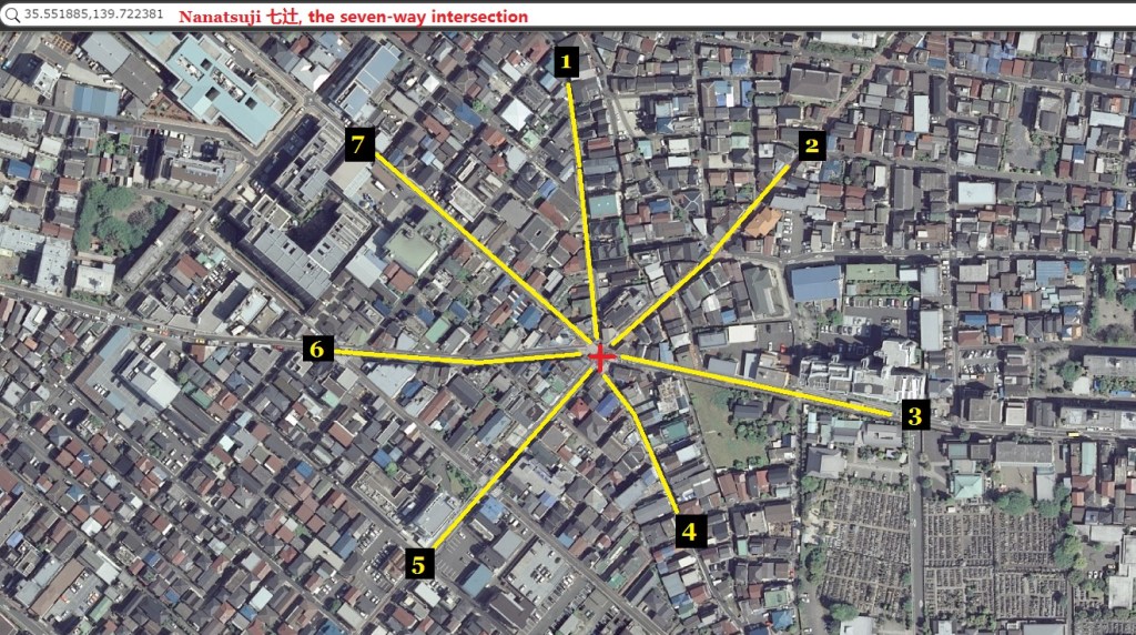
This post covers several danchi in the Ōta-ku neighborhoods of Minamikamata, Haginaka, Honhaneda, and Minamirokugō. These neighborhoods center around Nanatsuji 七辻, a 7-way intersection (map), supposedly one of only two in Japan.

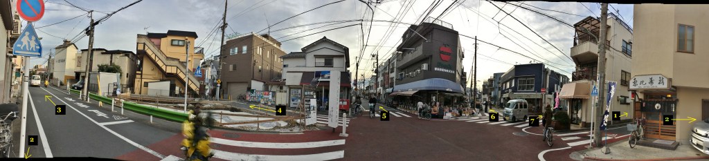
Here’s the intersection, cross-referenced to the above map:

A sign notes this is “Japan’s best model intersection” 「日本一ゆずり合いモデル交差点」

Now for some of the danchi in this area:

(390) Ward Minami-Rokugo 1-chome 3rd apartment 区営南六郷一丁目第3アパート (map)

(391) UR Minami Rokugo 2-chome Danchi UR都市機構南六郷2丁目団地 (map)

A couple of 13 or 14-story buildings next to the Tamagawa River:

Nearby is 六郷水門 Rokugo suimon (map), the floodgate between the Tamagawa River and the old 六郷用水Rokugo yōsui irrigation system.

(392) UR Amity Minami-Rokugo UR都市機構アミティ南六郷 (map)

(393) UR Minami0Rokugo 1-chome Danchi UR都市機構南六郷一丁目団地 (map)

(394) Toei Minami-Rikigo 1-chome Apartment 都営南六郷一丁目アパート (map)

(395) Ward Hon-Haneda 1-chome 2nd apartment 区営本羽田一丁目第2アパート (map)

(396) Ward Minami-Rokugo 1-chome Apartment 区営南六郷一丁目アパート (map)

(397) Minami…

View original post 58 more words

Leave a Reply

Fill in your details below or click an icon to log in:

WordPress.com Logo

You are commenting using your WordPress.com account. Log Out /  Change )

Facebook photo

You are commenting using your Facebook account. Log Out /  Change )

Connecting to %s

This site uses Akismet to reduce spam. Learn how your comment data is processed.