
Part I: the fishing village
The existence of Tsukuda / Tsukudajima 佃島 is no secret (map). The Japan Times has written about it (“Casting around in Tsukudajima“), bloggers write about it (佃島~島の名残り “Tsukudajima ~ island remnants”), and it’s easy to access from central Tokyo (it’s a 6-minute ride from Shiodome Station via the Oedo-line). Tsukudajima, until modern times, was a small fishing village, described as follows:
“The boat slides smoothly up onto the sand beach of a small but bustling island. Tsukuda island is a low, sandy islet at the mouth of the Sumida river, which runs through the heart of Edo. Apart from a few patches of trees and small vegetable gardens, the entire island is occupied by a thriving village of fishermen and boat pilots, who make their living from the commerce of Edo Bay”
Source: broken link: www us-japan org/edomatsu/tsukuda/frame html
Here is a view from 『武陽佃島』 Tsukada Island in the Musashi province, one of the Thirty-six Views of Mount Fuji 富嶽三十六景 by Hokusai 葛飾 北斎. (Musashi 武蔵国 was an old province that included Tokyo.)

Here’s another picture, facing south-ish, with Eitaibashi 永代橋 (Perpetual Bridge) in the foreground. Tsukudashima/Ishikawa is in the center, behind the dozen boats. The original Eitaibashi is long-gone, but a bridge with the same name exists today in roughly the same location. The original bridge was located about 100 meters upstream, connecting to Nihonbashi hakozakicho 中央区日本橋箱崎町 in the west.
And here’s a map, which I’ve rotated from the original so that north is near the top. Tsukudajima is the rectangle in the lower-center with the dotted line reaching its northwest corner. The larger land mass was known as Ishikawa 「石川島」. Together, Tsukudajima and Ishikawa are now known as Tsukuda 佃, part of Tokyo’s Chuo ward.

And map with more context. A red ‘佃島’ points to the island (source). Ishikawa 石川島 is noted in white.

Here, we see the relative positions of Tsukudashima and Eitaibashi, circa 1830-43 (map: 天保江戸図)

Though Tsukudajima is no secret, I only learned of its existence due to a long, rambling after-work walk. After an hour , I came across this:
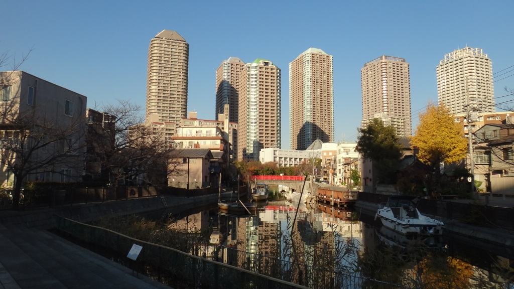

Yellow trees, a shrine, boats, a cute red bridge. These are a departure from the somewhat monotonous surrounding neighborhoods. I took a liking to this secret cove and I wanted to write about it, only I didn’t know what to say.
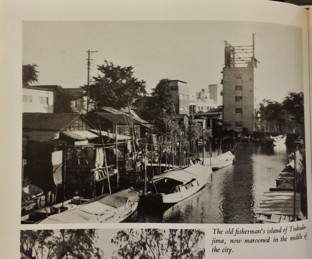
A year later I happened upon an old photograph, from maybe 1970, captioned,
“The old fisherman’s island of Tsukudajima, now marooned in the middle of the city.”
Below is a before-and-after from approximately the same spot:
Part II: Tokyo Sky Tree and the woodblock mystery
Before-and-after photos are the bread and butter of my blog, but sometimes they are too simple, too obvious. So I put this post on hold. Then I saw the following caption to a woodblock by Utagawa Kuniyoshi 歌川国芳:
“The bridge in the background [at right] is Eitaibashi, with the island of Tsukudashima beyond it.“

Tsukudashima, we meet again!
The picture is 東都三ツ股の図 (とうとみつまたのず) (“Caulking Boats at Mitsumata in the Eastern Capital“), circa 1831. At right is Eitaibashi, behind which is Ishikawa/Tsukudashima. At left, on the horizon, is a tall, thin tower.

Here’s a view from today, which contains many of the same features: at right is Eitaibashi, behind which, is today’s Tsukuda. At left, on the horizon, is a tall, thin tower: Tokyo Sky Tree.

What is the tower from Kuniyoshi’s picture? And did this tower predict Tokyo Sky Tree, built nearly 200 years later?
1. What is it?
Wooden towers, used to watch for fires, were a common feature of the Edo era. Here is a replica of a common 火の見櫓 (hinomiyagura), or fire lookout. It’s located just a few feet from Monzennakacho Station 門前仲町駅 (map) in Koto-ku:
Monzennakacho watchtower 門前仲町 火の見櫓

In the woodblock print, there is a watchtower, which is dwarfed by the tall mystery tower. Some blogs call the mystery tower a 火の見ヤグラ firewatch scaffold, though others disagree. The following picture is from きたろう散歩 Kitarou sanpo, a very good source (broken link: hiroshige-kitarou blog so-net ne jp/2011-05-06):

From what I can tell, the tall tower has been something of a mystery to contemporary Japanese bloggers. Their best guess is that this is a water drilling tower 井戸掘りの櫓. Here is a modest version:

There is a theory that Kuniyoshi’s tower is so tall because the shallow groundwater would have contained salt. (In contrast, others contend that this was NOT a well-digging tower, as the salt content below the island would be too high.) I am ready to believe it is a water-drilling well, as it would explain the structure’s temporary appearance. (Broken link: hiroshige-kitarou blog so-net ne jp/2011-02-23)
Here is another print by Kuniyoshi, from 1842: 子供遊金生水之掘抜, (Kodomo asobi kinjôsui no horinuki) “Children Playing as Diggers of the Well of Golden Water” (source). This is cited as the best evidence that the large tower is in fact a well-digging tower:

2. Did this tower predict the Tokyo Sky Tree, built nearly 200 years later?
The second curious thing about this tower is that its position on the horizon basically coincides with the position of Tokyo Sky Tree. As seen in the print and the photo from today, both towers are in essentially the same position, when viewed from the same vantage point. One blogger made the following image to illustrate this point:
Broken link: blogs yahoo co jp/koolooo1/12640032 html

This is known as “the picture of the mystery tower” 絵の謎の塔. One blogger asks, “スカイツリー建造は、江戸時代の時点で予言されていた?” (“The building of the Sky Tree, was it predicted at the time of the Edo era?“). Broken link: fsmaps com/?p=1056
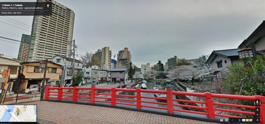
I have already shared with you the approximate location of Kuniyoshi’s photo, which is consistent with a website that presents this photo as their evidence. This photo differs from the one I shared above in that mine is a 180-degree view, whereas their photo is more limited and excludes the Eitaibashi. This is roughly HERE (Google StreetView). Another blog has similar pictures.

What do you think? Did Kuniyoshi foresee the future?
Links & Resources:
- 江戸名所永代橋佃島 Edo attractions Eitai Bridge Tsukudashima (National Diet Library)
- Tsukuda jima is sometimes translated as Tsukuda shima; jima and shima are different pronunciations of ‘island’
- Tsukishima and Tsukudajima Alley Walking Map
- (7) Tsukishima 月島
- Life in Edo Tsukudajima; broken link: us-japan org/edomatsu/tsukuda/frame html
The mysterious tower:
- きたろう散歩番外編”歌川国芳の浮世絵VS東京スカイツリー(6)(最終回) Kitaro walk extra edition “Kuniyoshi Utagawa of ukiyo-e VS Tokyo Sky Tree (6). Broken link: hiroshige-kitarou blog so-net ne jp/2011-06-12
- The most extensive post: きたろう散歩番外編”歌川国芳の浮世絵VS東京スカイツリー(5)(注)” [歌川国芳] Kitaro walk extra edition “Utagawa Kuniyoshi Ukiyo-e VS Tokyo Sky Tree” [Utagawa Kuniyoshi] (May, 2011); Broken link: hiroshige-kitarou blog so-net ne jp/2011-05-06
- きたろう散歩番外編”歌川国芳の浮世絵VS東京スカイツリー(1)(注)” [歌川国芳] Kitaro walk extra edition “Utagawa Kuniyoshi Ukiyo-e VS Tokyo Sky Tree” [Utagawa Kuniyoshi] (February, 2011); Broken link: hiroshige-kitarou blog so-net ne jp/2011-02-23
- 【あなたは信じる?】東京のシンボル・スカイツリーに秘められたシンクロニシティ [You believe? ] Synchronicity that has been hidden in a symbol of Tokyo Sky Tree
- 江戸の空にスカイツリー The Sky Tree in Edo sky
See also:
Scenes from “March Comes in like a Lion” 3月のライオン (Sangatsu no Raion):
Scenes from Toxic Avenger, Part 2:

[…] A fishing village, then a Sky Tree mystery […]
The other possibility is that the ange is from the actual Nakasu (that didn’t exist at this time, but just behind) the right bridge is Eitabashi, the left bridge is Mannen bridge (supported by two pillars like in Hokkusai’s pitcure) and that land in between is Kiyosumi. Sadly, in this case, the Tokyo sky tree is nothing close to the position drawn and this might just be a well digging or water drilling tower with just crazy scale.
Very interesting work. This mystery has been for long a source of struggle (and hopes) for me.
However, I don’t think the bridge on Kuniyoshi’s 1831’s print is Eitabashi. The simple positions of the Sumidagawa wouldn’t fit. Even the bridge on the left would be the Shinobashi, but in this case it would be way closer than the Eitaibashi, and far from the tower. You also have to consider that in its present position, Eitabashi is more than a kilometer away from the old Mitsuma (actual neighbourhood of Nihonbashi Nakasu, just above Nihonbashi Hakozakichô). From Mitsumata, I would rather see this as the Mannen bashi, but not sure, it’s shown ith only two pillars by Hokkusai on the exact same year.
We also must notice the place called Mitsumata, that Kuniyoshi even titled his print didn’t exist anymore dring his whole life. The reclaimed land was distroyed with Nakasu during the Kensei reforms because it as holding several pleasures houses, and it reappeared around 1868. A print by Hiroshige called Mitsumata also has the same issue as it even shows the red lights Nakasu on the far banks of the Sumida while Hiroshige never saw by himself.
I tried to take a picture from the tip of Ishikawajima park and somehow, I think it works even better than from the Nakasu riverbanks, despite the bridge on the right missing, and with Eitaibashi as the bridge on the left.
In any case, I think this print, not as a representation of the Edo Kuniyoshi had in the eyes, but a work of imagination about the future of the Sumida banks with regular new reclaimed lands and bridges, added to the actual island…